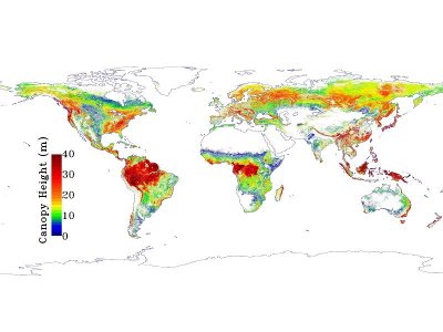
NASA led a project that allowed the creation of an accurate high-resolution map of the Earth’s forests and their height. This study was conducted by scientists from NASA’s Jet Propulsion Laboratory, Pasadena, California, the University of Maryland, College Park and the Woods Hole Research Center, Falmouth, Massachusetts.
The map, now available online, was created using two and a half million carefully selected laser measurements made in 2005 using the Geoscience Laser Altimeter System (GLAS), an instrument that uses the remote sensing LIDAR (Light Detection And Ranging, also known as LADAR, Laser Detection and Ranging) technology by the ICESat (Ice, Cloud and land Elevation satellite).
The ICESat satellite data have been improved by using data from other sources. Data taken with the MODIS (Moderate-resolution Imaging Spectroradiometer) of NASA’s Terra satellite were used to estimate the percentage of global tree cover. Altitude data were taken from the Shuttle Radar Topography Mission (SRTM) carried out by the Space Shuttle Endeavour in February 2000. Maps of altitude and precipitation were taken from the Tropical Rainfall Measuring Mission (TRMM) performed by NASA and Japan Aerospace Exploration Agency (JAXA). Other data were taken from the WorldClim database.
Dr. Marc Simard, lead scientist at JPL, said that knowing the height of the Earth’s forests is essential to estimate their biomass or the amount of carbon they contain. The map created can be used to improve global efforts of carbon monitoring.
[ad name=”Google Adsense 300″]
The forest height is a characteristic of Earth’s habitats yet is poorly measured globally. This new research may therefore be beneficial to studies of the variety of life that are found in particular parts of the forests or the various habitats.
The map depicts the highest points of the forest with a spatial resolution of one kilometer (0.6 miles). Approximately seventy ground sites around the world have been used to verify the data obtained.
The researchers found that in general forests height decrease at higher elevations and are the highest at low latitudes then decrease moving away from the tropics. The major exception is represented by tropical forests in Australia and New Zealand due to the presence of eucalyptus, which can be more than 40 meters (130 feet) high.
This research demonstrated the great potential for the space use of the LIDAR technology to obtain new information on the Earth’s forests. In order to monitor the health of the forests and other ecosystems in the long term is however necessary to launch new satellites. Obviously, this type of monitoring is essential to control a planet whose health at the moment isn’t very good.

