
This week at the UNESCO headquarters in Paris, France, the 5th International GOCE User Workshop is being held. It aims to present and discuss the findings made by ESA’s GOCE (Gravity Field and Steady-State Ocean Circulation Explorer) satellite. In particular, there was a presentation of a new ocean currents model, the most accurate ever produced.
In recent years, the very precise measurements of Earth’s gravity made by the GOCE satellite were in the spotlight, with the presentation of very precise gravitational maps of the geoid. However, during its mission accomplished between 2009 and 2013, the second objective of GOCE was the exploration of the oceans circulation, the OC in the satellite’s name.
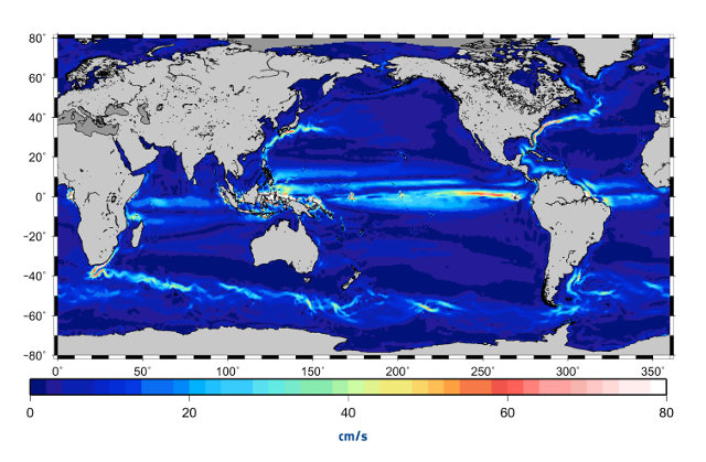
To create a model of ocean currents, scientists used as a reference the mean height of the sea surface measured in a period of over twenty years by other satellites such as ESA’s Envisat. By comparing these measurements with those of the geoid, it was possible to deduce the water levels in the various areas of the seas.
The next step was to calculate the flow of the waters and their speeds. This model created using data from GOCE was verified using buoys positioned in the sea in order to track the water flow. The result showed that this model is more accurate than all previous ones based on data obtained from space.
The accurate estimation of the currents on the oceans surface is essential to have a better understanding of the ocean dynamics. That’s because it will allow to obtain a better monitoring of the seas to understand their changes over time. This information will also be useful to forecasting because ocean currents also influence the weather.
This is not the first ecological study that used data collected by GOCE: a few months ago an analysis of data from this satellite was presented showing the ice melting in Antarctica. This research is also very important to understand the evolution of the global climate so the huge amount of data collected by GOCE keeps on being studied and analyzed.
[ad name=”AmazonScience”]
