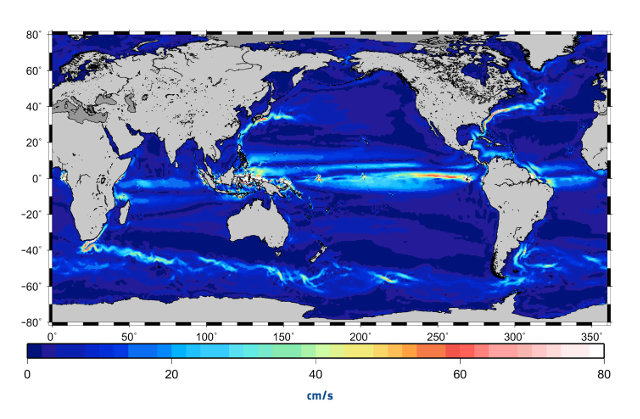
Space probes

Map of the ocean currents created using data from the GOCE satellite (Image ESA/CNES/CLS)

This week at the UNESCO headquarters in Paris, France, the 5th International GOCE User Workshop is being held. It aims to present and discuss the findings made by ESA’s GOCE (Gravity Field and Steady-State Ocean Circulation Explorer) satellite. In particular, there was a presentation of a new ocean currents model, the most accurate ever produced.

Geological map of the giant asteroid Vesta. Brown colors represent the oldest, most heavily cratered surface. Purple colors in the north and light blue represent terrains modified by the Veneneia and Rheasilvia impacts, respectively. Light purples and dark blue colors below the equator represent the interior of the Rheasilvia and Veneneia basins. Greens and yellows represent relatively young landslides or other downhill movement and crater impact materials, respectively (Image NASA/JPL-Caltech/ASU)

A little over a year ago, an atlas of the giant asteroid Vesta was presented but the analysis of the data collected by the Dawn space probe went even further. A special issue of the journal “Icarus” was all about Vesta presenting a series of geological maps that show details never seen before the characteristics of its surface.

David Williams of the School of Earth and Space Exploration at Arizona State University led a team of 14 researchers in a task that lasted about two and a half years. The team used the photographs taken by NASA’s Dawn spacecraft when it spent more than one year orbiting Vesta to create a geological map.

Philae's trajectory on the surface of the comet 67P/Churyumov-Gerasimenko (Image ESA/Rosetta/MPS for OSIRIS Team MPS/UPD/LAM/IAA/SSO/INTA/UPM/DASP/IDA)

The news hasn’t been officially released by ESA and the details have yet to be assessed after the analysis of the data sent by the lander Philae before it went into hibernation. Unofficially, one of the Philae’s instruments detected organic molecules in the tenuous atmosphere of the comet 67P/Churyumov-Gerasimenko created by the ice sublimation. Meanwhile, ESA has released the images captured by the Rosetta space probe that show Philae’s trajectory after it touched down for the first time on the comet’s surface.

Panoramic image of the surface of the comet 67P/Churyumov–Gerasimenko around the Philae lander (Image ESA/Rosetta/Philae/CIVA)

After the understandable enthusiasm felt last Wednesday for the success of the Philae lander with its landing on the comet 67P/Churyumov-Gerasimenko, the team had to face the harsh reality. The area in which it ended up wasn’t the planned one and there it received much less light than expected. The consequence is that its batteries ran out of power a few hours ago making it hibernate. But before it worked for a few hours and transmitted a lot of data.

All this happened because the harpoons system that was supposed to anchor Philae to the ground didn’t work and the information gathered since then allowed to establish that it touched down three times before stabilizing. The instruments work but Philae was receiving much less sunlight than expected with serious consequences for the energy it had available for its instruments.

Present orbits of the fifth and sixth Galileo satellites launched together by Soyuz on 22 August 2014 , in red, compared to their intended position, in dashed green, and the position of the four satellites launched in 2011 and 2012, in solid green (Image ESA)

ESA has announced that one of the two satellites of the Galileo constellation launched on August 22, 2014 and ended up in the wrong orbit will be moved in the course of this month. A problem of the Fregat last stage of the rocket caused the insertion of the two satellites in an orbit very different from the planned one. If the corrective maneuvers will be satisfactory, they’ll be repeated for the other Galileo satellite in the same situation.